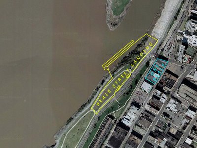
"Buzzing" BSL in a satellite
Here's the picture that got people buzzing today:

We carefully traced the RDC architect's drawing of the Beale Street Landing complex onto a Google satellite photo of the riverfront. As you can see, BSL (yellow outline) will consume a portion of Tom Lee Park -- an area used to stage concerts during Memphis in May. On the north end, BSL also covers a portion of the lower Cobblestones.Read more »
Labels: Beale-Street-Landing

